Integrated Geospatial Surveying
FEDS delivers integrated geospatial intelligence across land, subsurface, and water- combining mobile mapping, ground penetrating radar, traditional survey, bathymetric survey, and handheld device methods into a single, unified dataset your engineers can act on immediately.
.webp)


.webp)


.webp)


Why Standard Survey Scopes Fail Complex Projects
The Ground Beneath You Is Unknown

Missed Deadlines Traced back to Survey Bottlenecks

Historical records are incomplete or scattered across vendors
Teams rely on vast, fragmented data from multiple vendors
Corridor & Linear Projects Are Systematically Under-Surveyed
Data That Isn't Decision-Ready & Compliance Non-Conformant
Multi-environment projects require integrated solutions
Reworks result in wasted time, materials, and adds unnecessary emissions
FEDS vehicle-mounted LiDAR and imaging systems capture roads, infrastructure, and built environments rapidly and at scale. A single mobilisation delivers georeferenced point clouds, 360° imagery, asset inventory data, and topographic features simultaneously — eliminating the need for multiple site visits. Ideal for highway corridors, utility networks, urban master plans, and large-scale asset management programmes across the UAE and KSA.


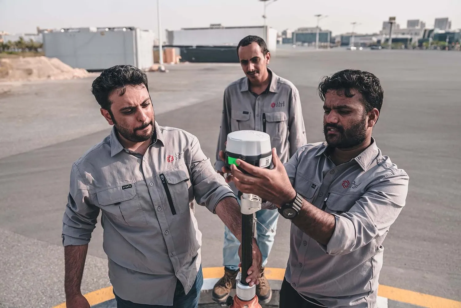
GNSS, RTK, total station, and precise levelling conducted by FEDS-licensed surveyors establish the certified accuracy control framework that anchors every other dataset. Our ground survey capability covers topographic surveys, cadastral and boundary work, setting-out, as-built documentation, and control network establishment — all delivered in DWG, GIS, and BIM-compatible formats, compliant with local authority standards across Dubai, Abu Dhabi, Riyadh, and Jeddah.
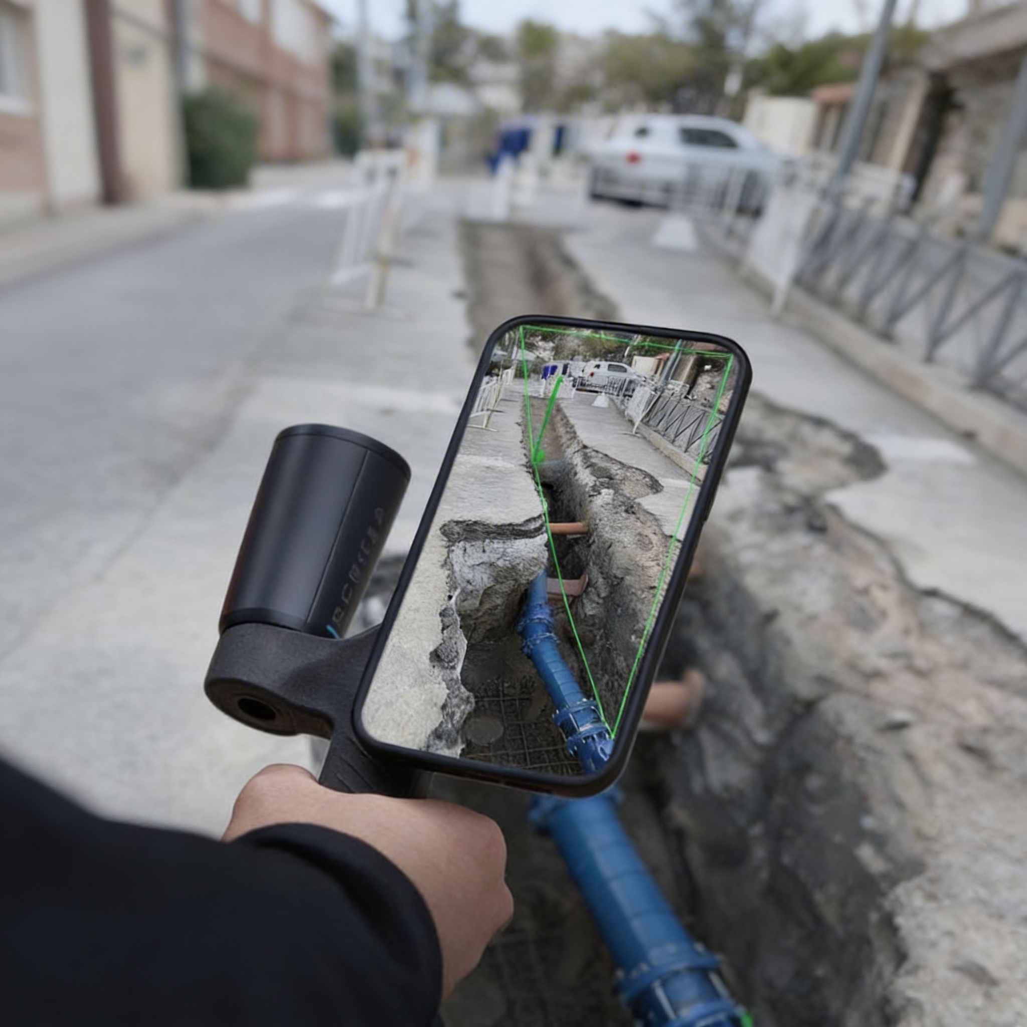
Our GPR survey service detects and maps buried utilities, subsurface voids, underground infrastructure, and concrete internal structures without excavation or disruption. FEDS integrates GPR data directly into GIS and CAD deliverables, producing subsurface utility maps that meet municipality, utilities and other large scale project requirements. Deployable on foot, vehicle-mounted, or as part of a combined mobile mapping run- giving you surface and subsurface intelligence in a single operation.

Where vehicles and vessels cannot reach, FEDS deploys handheld SLAM-based LiDAR, total stations, and mobile scanning devices to capture interiors, confined spaces, complex urban geometry, and tight infrastructure zones. This capability extends the geospatial dataset into tunnels, basements, MEP voids, historical structures, and any environment where conventional methods are constrained — with output accuracy and format consistency identical to the rest of the project dataset.
FEDS hydrographic and bathymetric survey teams deploy single-beam and multibeam sonar systems to map seabeds, riverbeds, harbours, marinas, and coastal zones with sub-decimetre accuracy. Deliverables include bathymetric DEMs, hydrographic charts, volume calculations for dredging and reclamation, and GIS-ready layers — produced to port authority and maritime authority standards. Survey coverage seamlessly integrates with adjacent land-side topographic datasets to eliminate the waterline gap.

Technical Capabilities
Multi-Method Field Capability

FEDS operates mobile LiDAR, sonar systems, GPR arrays, GNSS instruments, and handheld scanners under one operational roof. No sub-contracting, no coordination gap, no accuracy discontinuity between methods.
Data Accuracy and Integration
All FEDS datasets are co-registered, georeferenced to a unified control network, and validated through internal QA/QC before delivery. Surface, subsurface, and underwater data speak the same coordinate language — because they're captured and processed by the same team.
Deliverables Your Engineers Actually Use
.jpg)
Point clouds, CAD drawings, GIS layers, BIM models, hydrographic charts, GPR utility maps, and DEMs — formatted for AutoCAD, ESRI ArcGIS, Bentley MicroStation, Autodesk Revit, and project-specific authority requirements. Zero translation step. Immediate use.
Licensed, Certified, and Regionally Compliant

Aligned with UAE aviation and municipal regulations, FEDS is an ISO 21384-3:2023, ISO 9001, ISO 14001, ISO 45001 and ISO 27001 certified entity. All operations are conducted by licensed professionals under UAE (DLD, DM, DCAA, DEWA) and KSA (MOMRA, NEOM, ROSHN) authority frameworks. Regulatory submissions handled end-to-end.


.svg)
.webp)