
LAST UPDATED
April 24, 2026
READING TIME
10
Min
.jpeg)
With Earth Day now behind us, the global conversation around sustainability is finally shifting from awareness to execution. The hard truth of modern conservation is that good intentions are no longer enough. Healing damaged ecosystems, whether rejuvenating coastal wetlands or recovering post-wildfire burn scars, requires massive logistical coordination, extreme precision, and data that is both accurate and immediate.
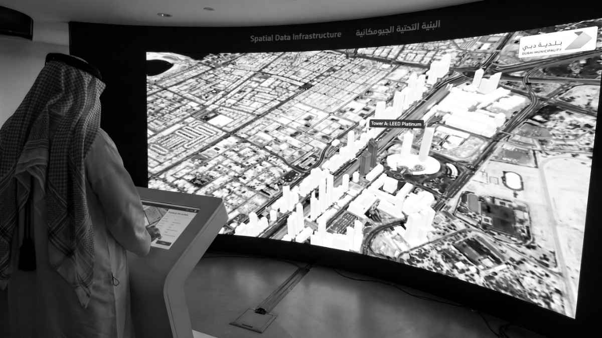
The most significant shift isn’t just the existence of new technology; it is the evolution of how that technology is deployed. Conservation organisations and environmental agencies are increasingly moving away from the burden of managing their own hardware, choosing instead to partner with specialised aerial service providers. By turning drone operations over to dedicated aviation and data experts, environmental teams are unlocking unprecedented scale and efficiency, allowing them to focus entirely on the science of saving the planet.
Planting trees is often viewed as a simple act, but restoring a mangrove forest is an incredibly complex science. Mangroves are hypersensitive to tidal flows and elevation. A difference of just a few centimetres in mudflat topography can mean the difference between a sapling drowning at high tide or drying out completely.
Historically, mapping these coastal zones required teams to trudge through deep, unstable mud, a slow, dangerous process that often damaged the exact ecosystems they were trying to save.
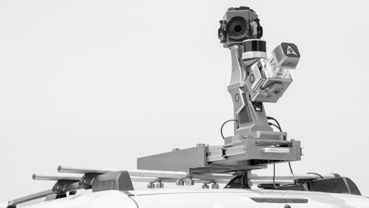
Today, advanced aerial service teams are changing the paradigm. By deploying heavy-lift drones integrated with high-density LiDAR and multispectral sensors, these teams can map hundreds of acres of tidal flats from the sky. The result is a hyper-accurate, 3D topographical model of the coast that reveals the exact micro-elevations of the mudflats. Conservationists can pinpoint the precise coordinates where water flow and elevation perfectly align for sapling survival. From there, specialised heavy-payload drones take over the physical seeding, taking the guesswork out of planting and drastically increasing survival rates.
.jpeg)
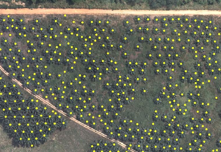
The power of managed aerial services extends beyond capturing data; it lies in analysing that data at an unprecedented scale. Consider the tedious task of ecological tree counting and segmentation, which is vital for monitoring forest inventories, managing irrigation, and tracking desertification. Traditionally, quantifying vast palm tree plantations required human crews to manually survey massive plots, a process prone to human error that could take weeks.
By pairing high-resolution drone orthomosaics with custom-trained artificial intelligence, dedicated service teams have fundamentally changed the mathematics of environmental inventories. Instead of a human spending 120 hours manually counting trees across a single square kilometre, AI-enabled engines can process the same area in under an hour, identifying assets with a 97% accuracy rate. This represents a staggering 99% reduction in processing time, instantly providing conservationists and agricultural directors with the precise inventory data needed to optimise resources and forecast ecosystem health.
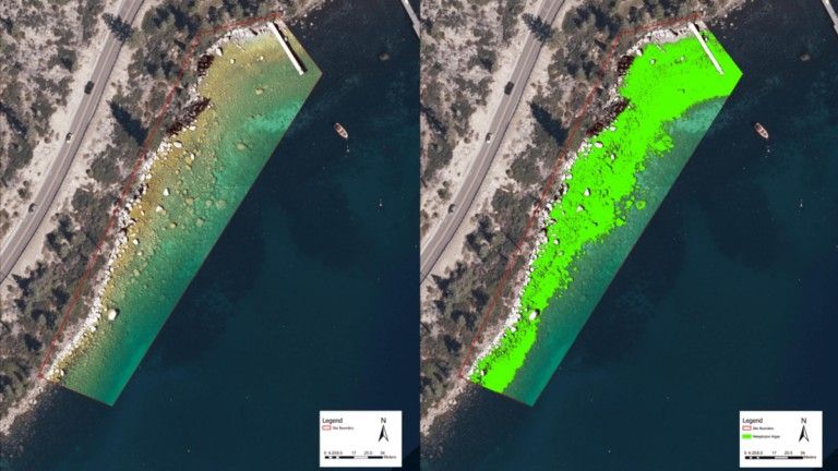
Some of the greatest threats to our ecosystems cannot be seen with the naked eye. Toxic cyanobacteria, commonly known as harmful algal blooms, can suffocate lake ecosystems and contaminate drinking water supplies long before human observers notice a colour change in the water.
Elite drone service providers are now employing hyperspectral imaging to detect these unseen shifts. By analysing the precise wavelengths of light reflecting off a body of water, these specialised sensors can identify the chemical signatures of toxic algae blooms while they are still in their infancy. This provides environmental agencies with an early warning system, allowing for targeted water treatment interventions weeks before a full-scale ecological crisis occurs.
Protecting endangered species across vast ecological reserves has historically relied on ground patrols, an inherently reactive approach limited by the sheer scale of the terrain and the speed of human deployment. Today, managed aerial services are completely changing this dynamic by integrating automated, thermal-equipped drone systems into park security infrastructures.
When ground sensors or perimeter alarms are triggered, advanced aerial teams can immediately deploy drones to scan the darkness. High-resolution thermal imaging quickly isolates the heat signatures of both vulnerable wildlife and unauthorised personnel, transforming a blind, multi-hour ground search into a precise, targeted interception. It is a massive force multiplier for conservation teams fighting organised poaching networks and monitoring herd migrations without disturbing the animals.
The common thread across these breakthroughs is the sheer complexity of the operation. Flying a drone is one thing; safely navigating complex airspace over a nature reserve, capturing API-grade LiDAR data, processing terabytes of information into actionable 3D models, and maintaining regulatory compliance is an entirely different discipline.
For organisations leading the charge in environmental conservation, partnering with a dedicated aerial service provider transforms an ambitious ecological goal into a measurable reality. It removes the friction of hardware maintenance, pilot training, and data processing, putting the focus back where it belongs: on the environment.
In the wake of Earth Day, the question for environmental agencies and sustainability directors is no longer whether aerial technology can help their cause. The question is how quickly they can integrate managed aerial data into their workflow to scale their impact.
For FEDS, this isn’t a distant vision. Through our operational presence in Tanzania, we are actively engaged in aerial conservation efforts across East Africa, supporting wildlife monitoring, habitat mapping, and environmental operations alongside regional teams on the ground. It’s one of the ways we’re extending the same managed service model, transforming environmental action in the Middle East to one of the most ecologically vital regions on the planet.
The science of conservation is evolving rapidly. Partnering with the right aerial service team ensures you are leading the charge, not just catching up.
Scale your conservation efforts with precision aerial data. Contact us today to get started.
📞 (+971) 4 425 0886 📧 enquiry@feds.ae 🌐 https://www.feds.group/


.webp)